Fellow Virtual Travelers and Historians,
Happy April Fools' Day! Unlike many of the interactions you may have today, we are telling the straight truth!
After a recent rousing Kung Fu martial arts workout, an observation was made that if we'd hiked up Huashan more, instead of taking the cableway, we'd be in better shape! Ironically, for this month's update we'd already planned to talk more about the Huashan cableway and Garmin watch GPS trek!
On December 3, 2016, we shared an email titled 'China Travel Log 2016 - Garmin GPS Tracks', in which we introduced our use of a Garmin GPS watch to create treks of our adventures:
http://www.sacredmountainodysseys.com/blog/2016/12/3/china-travel-log-2016-garmin-gps-tracks
China's sacred mountain of Hua is about a 3.5 hour drive from Xi'an. Xi'an is where the Terra Cotta Warriors are located. Once a person arrives in the city (Huayin) at the base of Huashan, much is involved to get up on the mountain. Here are those laborious steps, which we accomplished using an electronic translator (as we had no local guide on this part of our 2016 trip):
- taxi ride from the hotel to the Huashan tour bus station;
- 45 minute bus ride to the cableway station parking lot;
- 20 minute walk to the cableway station;
- wait in line for 2 hours to get on the cableway;
- 30 minute cableway ride across and up the mountain.
The price is the same whether you take the West Peak cableway, the Central Peak cableway or walk up from the base of the mountain. Walking from the bottom will take a day's hike just to get to Central Peak (if you take time to photograph along the way). You then would either opt to stay on the mountain overnight, or catch the last cable car back down the mountain.
So that we could see more territory on the mountain, we opted to use the new cableway that arrives at West Peak.
Here is a GoogleMap view of the cableway from to West Peak:
The GoogleMap view of the cableway station at the 'bottom' of the mountain:
To avoid the potential of dropping expensive cameras, Anita carried her iPod in her fanny pack and shot video of a small portion of the cableway ride (through VERY dirty windows that also had a lot of reflections). Here is a video of that raw footage:
When the weather is good, the sights on Huashan are breathtaking to say the least! The way is also treacherous and each step must be intentional, preceded by forethought.
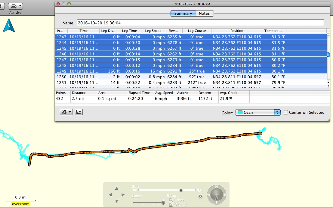
Hua Cableway GPS Data - The amount of data collected on a basic GPS watch is astounding! From time/date stamps, to distance, speed, elevation and GPS latitude/longitude, it captured it all! In this screen shot of the Garmin Basecamp software, the data collected on the cable car ride up to West Peak has been highlighted. This shows the cable car ride had an average speed of 6 MPH, covering 2.5 miles, with an average grade of 21.9%. The orange colored track represents the cable car data selected in the overlaying spreadsheet.

Hua Cableway on GoogleMap - Imagine a line halfway down this screenshot from the top. This is the approximate path of the cableway, stretching from left of 'Chijian' on the left hand side, to West Peak on the right side.
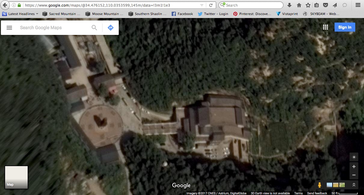
Hua Cableway Station - The cableway station at the 'bottom' of the mountain, is the large brown roof complex near the center of this screenshot. The 2 hour waiting line happened in the buildings on the left side of the large courtyard area.

Rural Hua - Blistering hot and humid in the summertime and freezing cold in the winter months, it is hard to imagine living in the 'foothills' of Huashan! Even though this is a famous and ancient mountain with centuries of rich history, current life in rural China is rough by any standard. Maybe there is running water, maybe not. Maybe there is indoor plumbing, maybe not. Maybe there is electricity, maybe not. You get the idea.

Fairy Mountain - Many of China's sacred mountains are called 'Fairy Mountains' and in this photograph, you can almost see little winged fairies flitting from point to point! The mists and breezes come and go, revealing majestic and breathtaking scenes beneath them!

Hua West Gate - Gateways in Chinese architecture have a long and complicated history. Over time, the 'paifang' or gateway architecture and ornamentation indicated the importance of the place beyond the gateway (e.g. Imperial Palaces vs. rural villages). More information about gateway architecture can be found here: https://en.wikipedia.org/wiki/Paifang

Hua Cable Car - Modern day cable cars are huge compared to the cable cars we've used in the past. Our 2002 expedition commonly offered cable cars that could hold only one American and their 20-pound backpack. Today's cable cars can hold 6 - 8 people per car!

Hua Hermitages - If you know what to look for, throughout Huashan small hermitages can be spotted high up on cliff walls. These were abodes hand hewn out of rock by monks seeking solitude in their paths of enlightenment. In this photograph, beside the leftmost people-sized cave, you can see hand hewn hand and toe holds for climbing up to the ledge above!

End of the Line - Arrival at the West Peak cableway station, found us INSIDE the mountain, entering a hermitage-like cutout that contained a tunnel leading to the nearest outside walkway.
So wherever you find yourself in life, just live in the moment and take one step at a time. That is the only way to conquer any mountain! Even when cable cars are available!
Blessings,
Dennis & Anita